1/3
ElevMaps screenshot 0
ElevMaps screenshot 1
ElevMaps screenshot 2
ElevMaps Icon

ElevMaps

Daniel G
Trustable Ranking Iconယံုၾကည္ရေသာ
1K+ေဒါင္းလုဒ္မ်ား
7MBအရြယ္အစား
Android Version Icon5.1+
Android ဗားရှင်း
1.7.29(18-02-2023)နောက်ဆုံး ဗားရှင်း
-
(0 ျပန္လည္သံုးသပ္မႈမ်ား)
Age ratingPEGI-3
ထည့္သြင္းပံု
1
ထည့္သြင္းရမည့္ဖိုင္ကို ေဒါင္းလုဒ္ဆြဲကာ ဖြင့္ပါ
2
Unblock AptoideAptoide is a safe app! Just tap on More details and then on Install anyway.
3
ထည့္သြင္းမႈကို ၿပီးေအာင္လုပ္ကာ Aptoide ကိုဖြင့္ပါ
app-card-icon
အေသးစိတ္မ်ားျပန္လည္သံုးသပ္မႈမ်ားဗားရွင္းမ်ားအချက်အလက်
1/3

၏ ရွင္းလင္းခ်က္ ElevMaps

ElevMaps is a powerful GPS tool with a simple and easy user interface.


ElevMaps is a 3D / 2D map viewer for your hiking trips, but not only ;

ElevMaps is perfect also for mountain bike, paraglide, and many outdoors activities ...


The 3D maps are rendered in OpenGL by combining map tile from various sources

with elevation data.


The maps can be displayed like classic map (North up) or with automatic rotation

(GPS orientation and Compass orientation)


ElevMaps is also a great map navigation GPS tool ... You'll be never lost with it !


Current features :


. View online/offline maps in 3D and 2D.

. Download maps areas for offline use.

. View offline maps downloaded with Mobile Atlas Creator (MOBAC)

The atlas format is OSMAND tiles storage.

. View Mapsforge maps/OpenAndroMap maps with different render themes.

. Perfect maps view with zoom level commands IN/OUT and screen fingers gestures integration.

. Import and view OziExplorer maps.

. Download and attach elevations for current downloaded maps.

. Use elevation data in SRTM3 format (stored in device and perfect for big maps)

. Track recording in KML/GPX format.

. Track builder for easy trips preparation in KML/GPX format.

. Track player with hiking mode or flight mode 3D in air (KML/GPX format)

. Import/Export tracks in KML/GPX format.

. Statistics window (altitudes, speed, distance ...)

. Search a place on the map (internet needed)


. And more features coming soon ...

ElevMaps တစ်ရိုးရှင်းပြီးလွယ်ကူပါတယ် user interface ကိုအတူအစွမ်းထက်ဂျီပီအက်စ်ကိရိယာတခုဖြစ်တယ်။


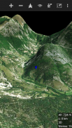
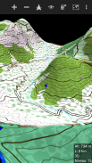
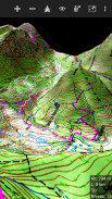
ElevMaps သင့်ရဲ့တောင်တက်ခရီးစဉ်များအတွက်တစ်ဦး 3D / 2D မြေပုံကိုကြည့်ရှုသူဖြစ်တယ်, ဒါပေမဲ့မသာ;

ElevMaps သောတောင်ပေါ်ဆိုင်ကယ်, Paragliding နှင့်များစွာသောအိမ်ပြင်လှုပ်ရှားမှုများလည်းစုံလင် ...


အဆိုပါ 3D မြေပုံများအားအမျိုးမျိုးသောရင်းမြစ်များမှမြေပုံ tile ကိုပေါင်းစပ်ပြီးအားဖြင့် OpenGL အတွက်ပြန်ဆိုနေကြ

မြင့်ဒေတာနှင့်အတူ။


အဆိုပါမြေပုံများအားဂန္မြေပုံ (တက်မြောက်ပိုင်း) များကဲ့သို့သို့မဟုတ်အလိုအလျောက်လည်ပတ်နဲ့ဖော်ပြပေးနိုင်ပါတယ်

(ဂျီပီအက်စ်တိမ်းညွတ်ခြင်းနှင့်သံလိုက်အိမ်မြှောင်ရဲ့ orientation)


ElevMaps သင်နှင့်အတူပျောက်ဆုံးသွားဘယ်တော့မှပါလိမ့်မယ် ... စတဲ့အကြီးအမြေပုံအညွှန်း GPS စနစ် tool ကိုပါ!


လက်ရှိ features တွေ:


။ ကြည့်ရန် 3D နဲ့ 2D တွင်အွန်လိုင်း / အော့ဖ်လိုင်းမြေပုံများ။

။ အော့ဖ်လိုင်းအသုံးပြုမှုအတွက်မြေပုံဒေသများ download လုပ်ပါ။

။ မိုဘိုင်း Atlas ဖန်ဆင်းရှင် (MOBAC) နဲ့ဒေါင်းလုပ်လုပ်အော့ဖ်လိုင်းမြေပုံများ View

  အဆိုပါ Atlas format နဲ့ OSMAND အုပ်ကြွပ်သိုလှောင်မှုဖြစ်ပါတယ်။

။ ကြည့်ရန် Mapsforge မြေပုံများ / OpenAndroMap ကွဲပြားခြားနားသောဆပ် themes များနှင့်အတူမြေပုံ။

။ စုံလင်သောမြေပုံများအား IN / OUT zoom အဆင့်ပညတ်တော်တို့ကိုအတူကြည့်ရှုမျက်နှာပြင်လက်ချောင်းများပေါင်းစည်းမှု gestures ။

။ မြေပုံများအားသွင်းကုန်နှင့် OziExplorer ရှုမြင်ကြသည်။

။ လက်ရှိဒေါင်းလုပ်လုပ်မြေပုံအဘို့အမြင့်တက် Download များနှင့်ပူးတွဲ။

။ (ကြီးတွေမြေပုံအတွက်ကိရိယာစုံလင်ထဲမှာသိမ်းထားတဲ့) SRTM3 format နဲ့မြင့်ဒေတာကိုသုံးပါ

။ KML / GPX format နဲ့မှတ်တမ်းတင်ကိုခြေရာခံ။

။ KML / GPX format နဲ့လွယ်ကူသောခရီးစဉ်ပြင်ဆင်မှုအဘို့အ track ဆောက်။

။ လေထဲတွင်တောင်တက် mode ကိုသို့မဟုတ်လေယာဉ်ခရီးစဉ် mode ကို 3D အတူ track ကစားသမား (KML / GPX ပုံစံ)

။ သွင်းကုန် / ပို့ကုန် KML / GPX format နဲ့ခြေရာခံ။

။ စာရင်းအင်းင်းဒိုး (ကုန်းပြင်မြင့်, အမြန်နှုန်းအကွာအဝေး ... )

။ မြေပုံပေါ်တွင်နေရာတစ်နေရာရှာရန် (အင်တာနက်လိုအပ်)


။ နှင့်ပိုပြီး features တွေမကြာမီလာမယ့် ...


ElevMaps - ဗားရွင္း 1.7.29

(18-02-2023)
အျခား ဗားရွင္းမ်ား
ဘာအသစ္ရွိလဲ- added Italian translation;- extended KML parser with new track format;- fixed some issues;

သုံးသပ္ခ်က္ သို႔မဟုတ္ အဆင့္သတ္မွတ္ခ်က္မ်ား မရွိေသးပါ။ ပထမဆုံး ျပဳလုပ္ရန္အတြက္ ကို ထည့္သြင္းေပးပါ။

-
0 Reviews
5
4
3
2
1
Info Trust Icon
ေကာင္းမြန္ေသာအက္ပ္ျဖစ္ေၾကာင္း အာမခံသည္ဤအက္ပ္သည္ ဗိုင္းရပ္စ္၊ ေမးလ္၀ဲႏွင့္ အျခားမသမာေသာ တိုက္ခိုက္မႈမ်ားအတြက္ လံုၿခံဳေရးစစ္ေဆးခ်က္ကို ေအာင္ျမင္ခဲ့ၿပီး မည္သည့္အႏၲရာယ္မွ် မရွိပါ။

ElevMaps - APK သတင္းအခ်က္အလက္

APK ဗားရွင္း: 1.7.29package: org.elevmaps
အန္းဒ႐ိုက္ ကိုက္ညီမႈ: 5.1+ (Lollipop)
ထုတ္လုပ္သူ:Daniel Gခြင့္ျပဳခ်က္မ်ား:10
အမည္: ElevMapsအရြယ္အစား: 7 MBေဒါင္းလုဒ္မ်ား: 165ဗားရွင္း : 1.7.29ျဖန္႔ခ်ိသည့္ ရက္စြဲ: 2024-03-16 14:26:17စခရင္အေသး: SMALLအေထာက္အပံ့ေပးနိုင္ေသာ စီပီယူ: x86, x86-64, armeabi-v7a, arm64-v8a
ပက္ေက့ဂ်္အိုင္ဒီ: org.elevmapsSHA1 လက္မွတ္: F5:DA:C1:E9:5B:9F:DD:7B:F7:B6:82:16:CD:D2:3F:65:A6:A5:86:1Eထုတ္လုပ္သူ (CN): Daniel Gheorghiuအဖြဲ႕အစည္း (O): homeေဒသဆိုင္ရာ (L): Iasiနိုင္ငံ (C): ROျပည္နယ္/ၿမိဳ႕ေတာ္ (ST): Romania

ElevMaps ၏ ေနာက္ဆုံးဗားရွင္း

1.7.29Trust Icon Versions
18/2/2023
165 ေဒါင္းလုဒ္မ်ား7 MB အရြယ္အစား

အျခား ဗားရွင္းမ်ား

1.7.28Trust Icon Versions
11/1/2023
165 ေဒါင္းလုဒ္မ်ား10 MB အရြယ္အစား
1.7.27Trust Icon Versions
27/12/2022
165 ေဒါင္းလုဒ္မ်ား7.5 MB အရြယ္အစား
1.7.26Trust Icon Versions
18/12/2022
165 ေဒါင္းလုဒ္မ်ား7.5 MB အရြယ္အစား
1.7.25Trust Icon Versions
15/12/2022
165 ေဒါင္းလုဒ္မ်ား6 MB အရြယ္အစား
1.7.20Trust Icon Versions
29/7/2017
165 ေဒါင္းလုဒ္မ်ား3.5 MB အရြယ္အစား
1.7.19Trust Icon Versions
28/2/2017
165 ေဒါင္းလုဒ္မ်ား3.5 MB အရြယ္အစား
1.7.18Trust Icon Versions
14/2/2017
165 ေဒါင္းလုဒ္မ်ား3.5 MB အရြယ္အစား

က႑တူအက္ပ္မ်ား

သင္ႏွစ္သက္ႏိုင္သည္မ်ားမွာ...